Sunday, December 1, 2013

Seven Sisters: Basalt and Bending Rifts

A few weeks ago I had the pleasure of walking the Seven Sisters trail in the Holyoke Range of western Massachusetts. The Holyoke Range is an unusual mountain range for the Eastern United States because it trends East-West. Most of the mountain linear ranges on the east coast like the Appalachians and Taconics formed as oceanic island arcs were smacked onto the side of the continent (here's a nice cartoon). So what's different about the Holyoke Range?

Overview of the Seven Sisters Trail (not sure how you get seven peaks...).
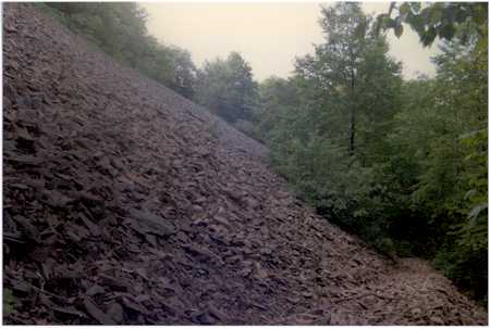
A few clues in the geology offer an explanation. The first is simply the rock type. While walking the Seven Sisters, you see a whole bunch of basalt. The trail continually goes up, over and around angular outcrops and talus slopes (image below) of basalt. Orogenies (a term that refers to the "smacking on" of island arcs described above) typically result in high grade metamorphic rocks and granitic magmatism, so what's all this basalt telling us?

A talus slope on Bare Mountain via Wikipedia
To figure this out, let's consider the broader geologic context of the area. The Holyoke Range lies at the northern terminus of the Metacomet Ridge that runs up the center of the Connecticut River Basin (see map below, the Metacomet Ridge is in red). By mapping faults and rock types, geologists have determined that the Connecticut River Basin is actually a continental rift that formed as Pangea began to break up 200 million years ago. Eventually, rifting in Connecticut stopped as extension shifted to the rift valley that would eventually become the Atlantic ocean, but not before erupting a considerable amount of lava in the center of the rift. This lava solidified into what is now the Metacomet Ridge.

So the Holyoke Range is essentially the terminus of the system of fissures that formed and erupted a whole bunch of lava that solidified as basalt. But why does it bend and turn east-west? Rifts are essentially propagating cracks and as a crack propagates it will take the path of least resistance, following weakzones (this is demonstrated nicely in East Africa, where the East Africa Rift splits into an eastern and western branch, wrapping around the strong Tanzanian craton). If the rift was following some pre-existing weakness, it could have turned if the weak zone happened to change orientation. So taking this all in, the east-west trend of the Holyoke Range is likely due the propagating Connecticut rift following some pre-existing weakness.

The Connecticut Valley Rift Basin - image source here.

As a final note - should you find yourself at the end of the Seven Sister's trail, looking for some food and a drink, drive on over to El Comalito and take your tasty burrito next door to The Moan and Dove. You will not be disappointed (if you doubt me, just ask @alkenones)!

Monday, November 18, 2013

Wind, Sand and Water.

When I was an undergrad (back in 2008), I ventured down to the Wakulla County in the pan handle of Florida to help out a professor with some field work in coastal wetlands. I slugged around in knee to waist deep mud, laying sediment traps and using a hand-held strain gauge to measure the mud's cohesion. The wetlands are separated from the ocean by sandy banks, only connected by small coastal streams that flow in or out, depending on the tide. Though we were there for the mud, I was most intrigued by the patterns in the sand.


Above, a clump of grass at the mercy of changing winds traces out concentric circles. Below, soft arcs are swept on top of faint ripple-marks. 


Below, recent high-water marks are recorded by horizontal layering.


We were down in Florida several months after Katrina and the storm's impact was obvious. Below is a section of the road that was washed out during the storm, opening a new inlet to the wetlands. 


Monday, November 11, 2013

Hard rime high on Moosilauke

The cold winds are rising! Winter is coming! And with it comes alien landscapes.

Hard rime deposited on Mt. Moosilauke.
When conditions are right, ice can capture the wind in remarkable ways. Hard rime forms when a cold fog blows through and droplets freeze onto the cold surfaces. It's a bit counterintuitive, but the rime forms on the windward side of the obstruction - meaning the protruding ice points into the wind rather than being deposited in its wake.

Scale-like rime on the windward side of a rock
I took these photos on two separate trips to the summit of Mt. Moosilauke in New Hampshire in the dead of New England winter. On the first trip, conditions were cold but not too windy on the summit, making the wind-sculpted ice even more surreal. On the second trip, summit conditions were what you would expect looking at the photos - subzero (Fahrenheit) temperatures and blistering wind to freeze your eyeballs shut.
Cold vegetation?
The photo above captures the flow of the wind especially well. The rime is aligned in an almost radial pattern, implying that the dominant wind direction during rime formation was perpendicular to the sign. The wind hit the sign, then flowed out radially along the sign's surface so that the rime grew inward to the center of the sign. That's my interpretation at least :)

Monday, October 28, 2013

Birds on the Baldfaces

The trek up the Baldfaces is one of my favorite hikes in the White Mountains of New Hampshire. The steep, exposed trail leads up overlapping granite ledges to a gently sloping summit with great views of the surrounding peaks.

From South Baldface, NH

The fast-changing weather in the Whites often leads to neat meteorological effects! As we hiked up to the south summit of the Baldfaces in the morning, the low-lying clouds warmed up and flowed up into the valleys. But they never quite reached us - the clouds evaporated about halfway up, leaving clear skies above.

Cedar waxwings!
In addition to views of surrounding peaks, the clear skies provided great conditions to watch a small flock cedar waxwings fly about the low lying trees on the summit. Cedar waxwings aren't particularly rare, but their distinct eye-masks make them a fun bird to watch!

Close-up!

Monday, October 21, 2013

Pillow Talk


Ahh, quintessential New England.


Vinalhaven sits an hour offshore Maine by ferry and seemingly a century back in time. The small island houses a population of just over a thousand residents who live off the sea and the summertime migration of vacationers. It also holds an exceptional exposure of a solidfied magma chamber that has been uplifted, turned over and eroded to reveal an entire cross-section. I featured a photo from Vinalhaven last week, but couldn't leave it at just one...

Cross-section of pillow basalts intruded into magma
Usually pillow basalts form underwater. As lava erupts, the lava in direct contact with the water quenches, forming a hard pillow-shaped shell (here's a nice photo). The magma chamber on Vinalhaven, however, preserves pillows of a different sort. The pillows pictured above formed as fresh, hot magma intruded into an already cooled, but not yet solidified magma chamber. The cooler magma was still hot enough to deform, so these pillows ended up more like smooshed Hershey kisses. 

The dock at Hurricane Island

If you take a geologist to Vinalhaven, expect to be there a while. And if possible, try to stay overnight with the good folks of the Hurricane Island Center for Science and Leadership on the nearby Hurricane Island. The Hurricane Island Foundation renovated abandonded Outward Bound buildings and repurposed them to facilitate educational programs in a natural setting. In addition to their on-island educational program, they help organize geology field trips, providing boat transport, sleeping arrangements and awesome home cooked meals. Just bring your own pillows.

Sunday, October 13, 2013

A tale of two squishies and modern art

Rocks usually seem to be permanent, solid fixtures on the Earth, but occasionally I come across a rock that blurs the line between solid and liquid. These rocks preserve fluid-like behavior in crystalline form and can envoke a sense of abstract expressionism, perhaps reminiscient of a Jackson Pollrock painting (I'm so sorry). Today's rocks come from islands on opposite ends of the U.S. - Antelope Island in Utah and Vinalhaven in Maine.

Antelope Island juts out into the south end of the Great Salt Lake in Utah. In addition to holding evidence of isostatic rebound (due to the draining of Lake Bonneville), Antelope Island is home to a type of rock called a migmatite. Part metamorphic and part igneous, migmatites form when a metamorphic rock like a gneiss is submitted to high temperatures and high pressure. The high temperatures weaken the rock and causes a little bit of melting, and the high pressure squishes the minerals into a tapestry of swirls. If you're interested in numbers, this paper reports that the migmatites of Antelope Island reached a temperature of 1300-1450 F (700-785 C) and a pressure as high as 400 MPa. To put the pressure into perspective, if the pressure is just due to being buried, these rocks would have been about 7.5 mi (12 km) below the Earth's surface!

Migmatite (1m wide), Antelope Island UT
Vinalhaven, an island off the coast of Maine, is home to a solidified magma chamber (here's a description of the geologic history). After cooling and solidify, subsequent erosion and tectonic rotation now allows us to walk across a magma chamber from top to bottom and observe many examples of magma frozen in the act of flowing. The rock in the photo below captures two magmas of different viscosities coming in contact. When two immiscible fluids (fluids that can't mix) contact each other, an instability called viscous fingering can arise, resulting in fingers of the less viscous fluid reaching into the more viscous material.

Magma mixing preserved in a solidified magma chamber, Vinalhaven ME

Rocks like these are nature's canvases. Even after the paint dries, some essence of motion is captured. From that motion, we can understand aspects of a rock's origin or simply appreciate the brush strokes in an abstract sort of way.

Monday, October 7, 2013

Catching air on Mauna Loa

The climb up Mauna Loa is an ethereal journey on a single lane road through overlapping lava flows to just shy of 12,000 ft (3600 m). At the end of the road is the NOAA observatory, an otherworldy collection of white buildings sitting on black basalt. Most visitors choose to drive up Mauna Kea to the space observatory, but if you prefer to ponder our Earth rather than distant twinkles, the NOAA observatory is a fascinating stop. The observatory is perhaps most famous for the longest continuous record of atmospheric CO2 (the Keeling Curve) - but the most fascinating tidbit I learned while there is that the extreme local topography of Mauna Kea and Mauna Loa creates a massive atmospheric downwelling that can bring air from the  stratosphere down to the summit! 

The NOAA observatory on Mauna Loa
The road up Mauna Loa cuts through lava flow after lava flow, offering ample opportunity to practice your GEO-101 relative dating skills. The photo below shows a series of overlapping flows (of both the a'a and pahoehoe and variety) with an added spatter cone bonus! If you're worried about acclimating to the elevation, just bring along a geologist and the drive will take a long time...

Overlapping flows with a spatter cone along the road up Mauna Loa

Sunday, September 29, 2013

Kīlauea Iki - lava and life

The hike across the floor of Kīlauea Iki offers impressive views of a once molten lava lake (check out this video for some amazing footage of the fire fountain during the 1959 eruption).

The floor of Kīlauea Iki - note polygonal cracks, and the well-tread trail

There are plenty of exciting geologic details - olivine phenocrysts, polygonal cracking (visible in the photo above, here's a paper on their formation), active steam vents - but there is also a surprising amount of life. Most striking are the blossoms of the ōhiʻa lehua, lonely frontrunners in the inexorable march of vegetative reclamation, splashing the landscape with red. The contrast is a reminder that eruptions not only destroy, but resurface and rejuvenate. The newborn rock hosts species endemic to Hawaii, adapted to live on freshly cooled flows.


ōhiʻa lehua (metrosideros polymorpha)

Friday, September 20, 2013

Waimea Canyon

Waimea Canyon: layers of solidified lava on the island of Kauai, HI

Waimea Canyon on the island of Kauai in Hawai'i is impressive. Beyond the surreal beauty of standing on the edge of a 3000 ft (900 m) cliff, there are a some fascinating details in the rock.

First off, these aren't layers of sedimentary rock, but igneous basalt! They formed by the solidification of lava flow upon lava flow upon lava flow over several million years! That's pretty darn unusual - every other layered canyon I know of cuts through layers of sediment.

Secondly, the layers are remarkably horizontal and undisturbed. What's so special about that? Well when lava flows down the side of a volcano and solidifies, the solidified rock layer dips with the slope of the volcano (you can't see it in the photo, but the west side of the canyon actually has layers that slope gently).  Horizontal layering of lava only happens when lava is fills in a hole; the lava flows down, settles and solidifies. So what happened here? It turns out that about 4 million years ago, the volcano collapsed, leaving a huge depression and then over the next several million years lava flowed in and filled the depression.

Gneiss Views: Introduction

Much of my time is spent outdoors hiking, rock climbing, walking and sitting. Being a geologist of sorts, the landscapes I journey over often provoke more than simple appreciation of nature - the scene we see is the culmination of a process, not just a static beauty. In this blog I'll share some photos and stories of places I've visited, showing the world from the perspective of a theoretical geophysicist on vacation in the field.

The next few posts will contain photos and accounts from a recent trip to Hawai'i.