Monday, January 6, 2014

Snowbows, rockfish and bobcats in Yosemite

My recent trip to California prompted me to pull up photos I've taken from previous trips, so here are some from Yosemite! I took all the usual shots of Half Dome and El Cap, but I'm not going to bother showing you those when there are thousands of photographs from much better photographers than myself.

I visited Yosemite in early December of 2012 during an unusually warm stretch. The valley and the majority of trails were still free of snow and I was able to do a few day hikes up to the valley rim. The first day, I hiked up 2600 ft (790 m) to the top of the Yosemite Falls. In December, the torrent of Yosemite Creek slows to a tranquil pace, and the flow into the edge is a shower-like mist rather than roaring waterfall. At the first main landing of the falls, the cool temperatures and reduced flow combined to create the unusual site below:

Snowpile at the base of Upper Yosemite Falls
That is a several meter tall pile of snow! The mist created by the water fall was freezing, precipitating and piling up! And for good measure, there's a rainbow thrown in. Yosemite magic.

Up near the top of the falls, I came across these cool little guys:
centimeter scale dioritic inclusions
The little dark blobs are tens of centimeters long and sitting in classic Yosemite granite. Based on a bit of googling (see figure 15 here), the blobs are dioritic . What's neat about these inclusions is that (1) they're all stretched in the same way (this is called a stretching lineation) and (2) they're globular. The shared direction is a record of past stresses in the rock and the inclusions' morphology indicates that the stretching of these inclusions occured while the rock was still hot and relatively squishy.

On the second day, I hiked up the Mist Trail by Vernal Falls (usually closed by this time of year) up to the back of Half Dome (which was closed) and looped back around and down the John Muir Trail. There were spectacular views of falls and frozen water spray, but the treat of the day occurred within the first few miles, when I caught site of this bobcat hanging out right by the trail:
Lynx Rufus in on the Mist Trail in Yosemite Valley
No, that's no housecat. Based on the white splashes on the inside of its ears the general coloring and little bobtail visible in the blurry photo on the right, I'm fairly sure this is Lynx Rufus (here's a much nicer photo).

Thursday, January 2, 2014

San Francisco Foodie Highlights

For the final post recapping my recent trip to California (AGU and Science, Bicycle-Camping), I wanted to briefly mention some of my food ventures. San Francisco has some great restaurants so I always try to explore as much as possible while there. Here are my top three meals (from a restaurant) from this year's trip, in no particular order. 

Burrito Heaven

La Taqueria sits in the heart of the Mission District and it is the heart of burritodom on Earth. The carnitas was tender and savory, there was some cheese but not too much, there was no rice (which in my opinion does not belong in a burrito), and the tortilla was steamed and soft. The other food is probably great, but I don't know if I'll ever be able to go here and not get a burrito.

Tasty Sushi

I've eaten a fair bit of sushi while in San Francisco, and  Hamano Sushi in Noe Valley is probably the best I've had yet. The rolls were great, the apple-walnut-shrimp appetizer was fantastic and I really enjoyed the soba (buckwheat) tea.

Noodley Goodness

Kim Than lies in the Tenderloin, west of Union Square and serves tasty Asian seafood and noodle dishes. There are quite a lot of things on the menu so it's best to go with a group and share everything - the larger tables have lazy susans to assist. I can't remember the names of anything we got, but it was all fantastic. Some noodles, some soup, some fish, all good.

A few highlights from AGU

It's been almost full month since my last post, but I'm back to it! In the beginning of December I flew out to California for the annual American Geophysical Union Fall Meeting - a week-long gathering of thousands of earth and space scientists in downtown San Francisco. With over 22,000 attendees and a huge range of topics, there's a ton of exciting (and sometimes not so exciting) science on display at AGU. It's impossible to give a full overview of everything I learned, but here are a few research tidbits I found interesting.

Avalanches

Dr. Michaela Teich (WSL Institute for Snow and Avalanche Research SLF) and coauthors  are studying how forests influence avalanche flow in order to improve predictive capabilities of avalanche models. Parameters like tree type, tree height and tree spacing all affect the initial triggering of an avalanche as well as the dynamics during a flow. Dr. Teich has taken an empirical approach to calculate a detrainment coefficient, a measure of how much snow mass is captured by a given forest type. The detrainment coefficient can then be used in simulations of avalanches to better predict flow paths and avalanche risk.
     I find this problem particularly intriguing because of the differences in scales involved - the ability of a forest to slow an avalanche rushing down a mountainside depends on the characteristics of a forest, which is influenced by the structure of individual trees. One of the biggest challenges of theoretical research in the physical sciences is understanding how to fit together processes that occur on different spatial and temporal scales. So while it may not be possible to build an avalanche simulation that includes individual trees, it may be possible to include the affects of individual trees by considering how they contribute to a forest's ability to capture snow. (Citation: Teich et al., 2013 AGU Abstract C41B-0615, Evaluation and operationalization of a novel forest detrainment modeling approach for computational snow avalanche simulation)

Magma Migration

Dr. Wenlu Zhu (University of Maryland) presented an overview of impressive experimental work being done to constrain the permeability of partially molten rocks. When rocks melt in the mantle, they only melt a little bit. That small amount of magma, however, forms an interconnected network that allows the magma to migrate upwards. As magma gets closer to the Earth's surface, the flow localizes into increasingly larger pathways until finally collecting in magma chambers that then erupt. So the permeability in the upper mantle ultimately modulates how fast magma gets to surface and fuel volcanic activity.
      Besides the scientific merit, these experiments are an impressive feat of engineering - Dr. Zhu and her students take rock samples, bring them to high temperature and pressure so that they melt a little bit and then shoot X-rays through them. Because magma has different properties from solid rock, the X-rays can be used to map out the magma network (here's a link to an image showing the magma network). One of the more recent updates that Dr. Zhu showed, was work by graduate student Kevin Miller in which he took the magma network and input it to a fluid dynamics model in order to calculate the effective permeability of the network. (citation: Zhu et al, 2013 AGU Abstract, MR23C-01. Permeability Evolution and the Mechanisms of Porosity Change)

A ride through Marin County

Unlike many of my colleagues, I don't do field work in cool places. So when I go to conferences, I try to make the most of it!  For the past 3 years now, I've been going to San Francisco every Decemeber to attend the American Geophysical Union's Fall Meeting (here are a few highlights from this year's science) and I try especially hard to take advantage of being out in California. Adventures from previous trips I've added on after AGU include hiking in the Ventana Wilderness, camping in Yosemite Valley and romping around Mt. Diablo. This year, a good friend of mine convinced me to do a two day bicycle camping trip. We've both done a fair bit of road riding, but neither of us had ever done any overnight touring with camping gear. And it turns out it's not that much harder than just biking!

The journey began at the Berkeley BART station, where we lugged our bikes loaded with camping gear down the stairs. We hopped off at the downtown Embarcadero stop and mounted our bicycles beneath blue skies and sunshine on the streets of San Francisco. The plan was to bike through downtown San Francisco, over the Golden Gate Bridge into Sausalito, then 22 miles north to China Camp State Park (see the ride overview below).


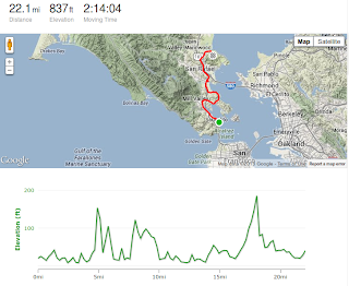
Overview of the ride from Sausalito to China Camp State Park
As we rode through downtown, it was obvious we were headed in the right direction because of the increasing number of tourists on rented bikes. There was one big hill on the way, and while blowing and huffing up it I was momentarily confused when a smiling, flip-flop wearing family leisurely pedaled past me without breaking a sweat. I felt much better about it when I noticed the cleverly disguised motors on their bikes.

The ride over the Golden Gate bridge was phenomenal. It was a rare clear day and we could see across the entire bay from the hills of Berkeley to the East and the mountains of Marin County to the North. It could be a tough stretch in typical windy and cloud-socked San Francisco weather, but it's a real joy with clear skies and sunshine.

From Sausalito, we made our way north on a mix of bike paths, busy roads and at one point a bridge wide enough for a single pedestrian. The network of paved bike paths through Marin County is impressive and if construction continues at the rate the current paths were built, it might be possible to do the same ride solely on bicycle paths in ten years from now. Even if that were possible, though, I would still make a detour to Paradise Drive on the Tiburon Peninsula. After a half-mile long and about a 150 ft high climb, Paradise Drive wraps along the coast going mostly down hill for the next 4 miles into Larkspur. The pavement is perfect and the views of the bay are great.

Once in Larkspur, the ride quality drops quite a bit. There are still some bike paths, but they're next to loud, busy roads and go by strip malls and decaying industrial centers. As far as urban riding goes, it's not bad (hey, at least there ARE some bike paths), but it's maybe not what you envision when you're biking to a campground. Maybe the only photo-worthy site is the amazing CalPark bicycle tunnel. Just make sure that when you make it out the other side you (1) pull ALL the way over to look at the map and (2) don't be checking your phone while biking behind someone who pulls over. Even crashes at 2 mph can give you ouches... not saying that happened... yeah... anyway...

The final push into China Camp State park is a mostly uphill 3.5 miles along N. San Pedro Rd. out of Santa Venitia. By the time we reached the park, the sun was long gone. As we coasted down the final hill, the moon was cresting over the horizon, lighting up the coastal marshes with an ethereal glow and I forgot that I had just biked 20 urban miles. We set up camp, threw on all our layers and sat down to eat a tasty meal of beans and corn masa tortillas.


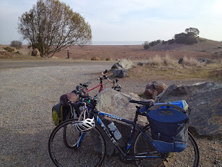
Fully loaded bikes at China Camp State Park

The next day, we packed up the tent and other gear, loaded up the bikes (photo above) and then did a little exploring in the tidal marshes of China Camp State Park. The park holds a surprising number of micro-ecosystems. The wetlands sit on the waterfront and reach inward, wrapping around hills covered in open groves of oaks. Farther inward, the oaks continue but the sparse ground cover makes it seem as if they're inviting you in. Sadly, we did not catch a glimpse the absurdly cute Salt Marsh Harvest Mouse (wiki, photo for evidence of cuteness), an endangered rodent that is endemic to the salt marshes of the Bay Area.

After walking a short quarter mile loop, we hopped back on the bikes and headed south through the rest of the park - by far the the best stretch of riding on the trip. The road spit us out back in San Rafael, and 8 miles later, we arrived at the Larkspur ferry just minutes before it shipped out for San Francisco. The ferry ride was a more representative taste of San Francisco weather; cold, wet and windy with the Golden Gate Bridge poking through fog and a teasing hint of sunshine in the distance. 

Alactraz with the Golden Gate Bridge barely visible through the fog